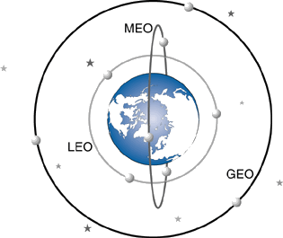
Fig. 1 - Satellite Orbital Paths
Satellites are launched into orbit, which is to say that they are shot up into the sky on rockets to get them up above the atmosphere where there is no friction. The idea is to get them flying so fast, that when they fall back to earth, they fall towards earth at the same rate as the earth's surface falls away from them. When an object's path around the earth, its "trajectory" matches the earth's curvature, the object is said to be "in orbit".
Orbital Distances
Any satellite can achieve orbit at any distance from the earth if its velocity is sufficient to keep it from falling to earth and it is free of friction from earth's atmosphere, and gravity is strong enough to pull it back towards earth. Distance from the earth can become a problem. The farther the satellite is from the earth, the longer it takes for a radio or microwave frequency transmission to reach the satellite. The altitudes at which satellites can orbit the earth are split into three categories:
- Low Earth Orbit (LEO)
- Medium Earth Orbit (MEO)
- High Earth Orbit (HEO)
Satellites can orbit around the equator or the poles, though technically they can orbit the earth on any elliptical or circular path.
- Equatorial Orbit
- Polar Orbit
| Orbit Distance | Miles | Km | 1-way Delay |
| Low Earth Orbit (LEO) | 100-500 | 160 - 1,400 | 50 ms |
| Medium Earth Orbit (MEO) | 6,000 - 12,000 | 10 -15,000 | 100 ms |
| Geostationary Earth Orbit (GEO) | ~22,300 | 36,000 | 250 ms |
| High Earth Orbit (HEO) | Above 22,300 | Faster than 36,000 | 300 ms or more |
LOW EARTH ORBIT (LEO)
Typical Uses: Satellite phone, Military, Observation
Satellites in low earth orbit (LEO) satellites complete one orbit roughly every 90 minutes at a height of between 100 and 500 miles above the earth's surface. This means that they are fast moving ( >17,000mph) and sophisticated ground equipment must be used to track the satellite. This makes for expensive antennas that must track the satellite and lock to the signal while moving.
Satellites in this orbital range also have a very small 'footprint'--that is, the surface of the earth that can be covered by the signal broadcast from the satellite is small. Thus, lots of satellites (35 or more) are required to make worldwide communication possible. At several million dollars per satellite, this is a very expensive satellite network to build and maintain.
MEDIUM EARTH ORBIT (MEO)
Typical Uses: Weather Satellites, Observation, spy satellites
Most of the satellites in medium earth orbit circle the earth at approximately 6,000 to 12,000 miles above the earth in an elliptical orbit around the poles of the earth. Any orbit that circles around the poles is referred to as a 'polar orbit'. Polar orbits have the advantage of covering a different section of the earth's surface as they circle the earth. As the earth rotates, satellites in polar orbits can cover the entire surface of the earth. Fewer satellites are required to create coverage for the entire earth, as these satellites are higher and have a larger footprint. Spy satellites typically use medium earth, polar orbits to cover as much of the earth's surface as possible from one satellite.
HIGH EARTH ORBIT (MEO)
Typical Uses: Space Observation, Weather Observation
High earth orbit places the satellite well outside the atmosphere and far enough away from the earth and its radiation sources to minimize the earth's impact on measurements and observations made by the satellites. However, at those altitudes the satellite cannot match the rotation of the earth and so are not geostationary.
GEOSTATIONARY and GEOSYNCHRONOUS (GEO)
Typical Uses for satellites in Geostationary Orbits: Television satellites, Long Distance Communications satellites, Internet, Global Positioning Systems (GPS)
At 22,240 miles above the earth, craft inserted into orbit over the equator and travel at approximately 6,880 miles per hour around the equator and which follow the earths rotation are said to be in Geostationary orbit. Geostationary orbits allow these satellites to maintain their relative position over the earth's surface. Since the satellite stays above the same spot on earth's surface, geostationary orbits are also called geosynchronous.
Craft in geostationary orbit don't need to be tracked, reducing the cost of earthstation antennas. Geostationary craft also have the advantage of height, giving them the broadest footprint (the signal broadcast covers the most earth surface), but this same height makes them unsuitable for Voice, Voice over IP and other latency-sensitive services due to the ground-satellite-ground propagation times (225 ms round trip or more). Additional power and larger dishes are also required to boost the signal to the satellite and receive the signal on the ground. Signals in geostationary systems also must pass through the entire atmosphere and suffer the greatest dissipation of all three orbital systems.
Ground stations in the northern hemisphere point south to the equator to send and receive to satellites. Ground stations in the southern hemisphere point north to communicate with the same satellites. Geostationary satellites do have one small limitation. Ground stations that are too far north or south (at the poles) cannot 'see' the geostationary satellite as the curve of the earth is between the ground station and the satellite. Thus, satellites in other orbits must be used.
Geostationary satellites are 'parked' in positions over the equator to maximize coverage over the inhabited portions of the earth. This area in space forms a belt and is referred to as the 'Clarke Belt' because it was noted science-fiction author Arthur C. Clarke that was the first to propose the idea.
POLAR ORBIT
A satellite in this orbit flies over the earth from pole to pole. They are typically inserted at lower orbits. Many polar orbits are elliptical in nature, and most polar craft are in the MEO altitude. This orbit is most commonly used in surface mapping and observation satellites as they allow a satellite which orbits the earth to take advantage of the earth's rotation to cause the entire surface of the earth to pass below the satellite. Many of the pictures of the earth's surface in applications such as Google Earth come from satellites in these polar orbits.
ELLIPTICAL
An elliptical orbit is an oval shaped orbit used to place the orbit close to earth in specific locations and to orbit at specific intervals. An elliptical orbit has two critical distances called apogee and perigee. Perigee is when an orbital object is closest to the earth. Apogee is when it is farthest away. Elliptical orbit satellites cover the polar regions where the geostationary satellites cannot reach.